Final report for Day2 of the Western Washington Severe Weather blog.
The KIRO radar view isn't very accurate at the moment. It isn't snowing here at all, and a friend just called from his waterfront home on Oyster Bay, and it's rain/freezing rain mixed there as of 11:58pm. You'd never know it by the above radar image.
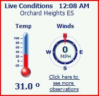
The temp still reads 28 from MSN, Schoolnet shows 31 degrees.
The National Weather Service in Seattle has issued a WinterWeather Advisory for The Lowlands of the Puget Sound area and the northwest interior of western Washington... which is in effect until noon PST Sunday.
The combination of sub-freezing air moving into western Washington from the north and showers associated with an upper low will produce 1 to 3 inches of snow tonight across The Lowlands of the Puget Sound region and the northwest interior. Another 1 to 2inches of snow will fall Sunday morning as showers decrease from the north.
The biggest snowfall totals tonight will occur in western Whatcom... Skagit... and Snohomish counties where snow began earlier this evening and temperatures have been below freezing. This is also where snow is more likely to accumulate on roads. Snowfall in the Seattle area and over the south Puget Sound region will likely be somewhat less... but it will probably stick on roads by morning as temperatures fall below freezing.
With temperatures falling well below freezing overnight... moisture on roads and sidewalks will turn to ice. So people should expect difficult traveling conditions later tonight and Sunday morning along with snow accumulations of 1 to 3 inches.
A Winter Weather Advisory means that periods of snow will cause travel difficulties. Be prepared for slippery roads and limited visibilities... and use caution while driving.


No comments:
Post a Comment